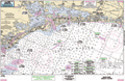
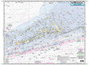
Nearshore: East Cape to Naples Bay, FL
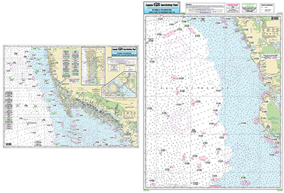
Chart #: NAP38
MSRP: $21.95 Your Price: $20.45
Click Here to
Order This Product
Nearshore 20 - 30 miles off. Chart is 19 x 26 inches, double sided, and laminated Florida coastline
Side A: from East Cape to Morman Key. Side B: from Morman Key to Clam Pass, includes inset of Naples Bay and Chokoloskee Bay. All charts include wrecks, rigs, reefs, shoals, fishing areas, amenities and restrictions. Please refer to our nearshore, offshore, and small boat/kayak charts this area. Uses NOAA Charts 11429 & 11431
Click Here to view all
Products in our FLorida Gulf Coast Category
|
|
|
|
[ID][/ID][AID]Y[/AID][PID]p[/PID]
|
|
|
|
|
|
|
|
|
|
You May Also Be Interested In! |
|
|
|
| |
|
| |
| ------------------------------------------------- |
|
|
| |
| ------------------------------------------------- |
|
|
| |
| ------------------------------------------------- |
|
|
| |
| ------------------------------------------------- |
|
|
| |
| ------------------------------------------------- |
|
|
| |
|
|
|
|