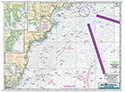
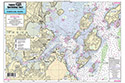
Nearshore: St George River, ME to Penobscot Bay and River
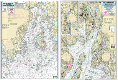
Chart #: PBR61
MSRP: $21.95 Your Price: $20.45
Click Here to
Order This Product
Nearshore chart 20-30 miles off coast/Inshore Chart 1-2 miles off coast, double sided, laminated, 19 x 26 inches, Maine
Side A, Nearshore Chart St George River to Penobscot Bay. Side B: Inshore Chart of Upper Penobscot Bay up the River to Bangor, with an inset of Belfast Harbor. Please refer to our inshore, nearshore, offshore, bathymetric and small boat/kayak charts in this area. All charts include GPS coordinates, wrecks, reefs, shoals, fishing areas, amenities and restrictions. Uses NOAA Charts 13302 & 13309
Click Here to view all
Products in our Maine Category
|
|
|
|
[ID][/ID][AID]Y[/AID][PID]p[/PID]
|
|
|
|
|
|
|
|
|
|
May Also Be Interested In |
|
|
|
| |
|
| |
| ------------------------------------------------- |
|
|
| |
| ------------------------------------------------- |
|
|
| |
|
|
|
|