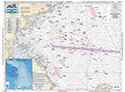
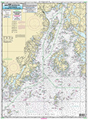
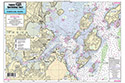
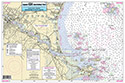
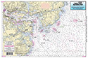
Nearshore: St George River, ME to Porstmouth, NH
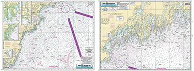
Chart #: GEP60
MSRP: $21.95 Your Price: $20.45
Click Here to
Order This Product
Nearshore chart 20-30 miles off coast, double sided, laminated, 19 x 26 inches, Maine and New Hampshire,
Side A, Portsmouth NH north to Cape Elizabeth ME Detail of Perkins Cove, Wells Harbor, Cape Porpoise Harbor and Kennebunk River. Side B, Cape Elizabeth to St George River Please refer to our inshore, nearshore, offshore, bathymetric and small boat/kayak charts in this area. All charts include GPS coordinates, wrecks, reefs, shoals, fishing areas, amenities and restrictions. Uses NOAA Charts 13286 & 13288
Click Here to view all
Products in our Maine Category
|
|
|
|
[ID][/ID][AID]Y[/AID][PID]p[/PID]
|
|
|
|
|
|
|
|
|
|
May Also Be Interested In |
|
|
|
| |
|
| |
| ------------------------------------------------- |
|
|
| |
| ------------------------------------------------- |
|
|
| |
| ------------------------------------------------- |
|
|
| |
|
|
|
|