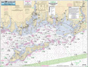
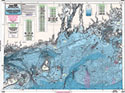
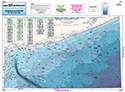
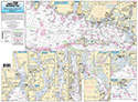
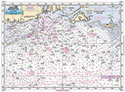
Inshore: Montauk, Peconic and Orient Bays, NY
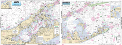
Chart #: MP108
MSRP: $21.95 Your Price: $20.45
Click Here to
Order This Product
An inshore chart 1-2 miles off the coast detailing the bays Chart is 19 x 26 inches, double sided, and laminated. New York coastline.
Tip of Long Island, Montuk, including Gardiners and Peconic Bays. A detail fo both forks. All charts include GPS coordinates, wrecks, reefs, shoals, fishing areas, amenities and restrictions. Also refer to our inshore, nearshore, bathymetric, and offshore charts. NOAA Charts 12358 & 13209
Click Here to view all
Products in our New York Category
|
|
|
|
[ID][/ID][AID]Y[/AID][PID]p[/PID]
|
|
|
|
|
|
|
|
|
|
|
|
| |
|
| |
| ------------------------------------------------- |
|
|
| |
| ------------------------------------------------- |
|
|
| |
| ------------------------------------------------- |
|
|
| |
| ------------------------------------------------- |
|
|
| |
| ------------------------------------------------- |
|
|
| |
| ------------------------------------------------- |
|
|
| |
|
|
|
|